CAA Certified
We are Civil Aviation Authority Certified (Rule, Part 101 & 102. Use of Unmanned Aerial Vehicle (UAB’s)).
Our drone is a DJI Phantom 4 RTK which, unlike most of the drones on the market, makes use of a mechanical shutter which results in sharper images and leverages real-time kinematic positioning (RTK) ensuring centimeter accuracy.
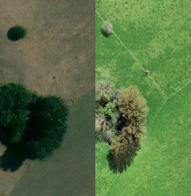
Drone vs satellite imagery
While it is possible to draw farm boundaries using existing satellite imagery there are a few drawbacks to this approach:
- Accuracy: Satellite imagery is accurate to between 5 and 10 meters – this means that the fence line that is drawn on the map may be inaccurate.
- Resolution: Satellite imagery has a resolution of 0.5 to 10 meters per pixel which reduces your ability to pinpoint features like troughs and gates
- Recency: Satellite images can be years old and therefore will not reflect any changes to boundaries, roads or buildings
A drone map flown at 100 meters above ground level will generate an image with a resolution of 2.5cm per pixel and will be accurate to within 5cm.
Deliverables
Once the farm has been flown the individual images are joined together to create a geospatially accurate orthophoto.
This orthophoto is then used to digitize all the relevant farm features – paddocks, races, drains, trough, buildings etc.
Each of the paddocks are labeled with the name and size in hectares and the effective/overall areas are calculated.
The primary output is a GeoJson or Shape file which can then be imported into a third party system.
We also offer printed material:
- A0/A1 full colour laminated and block mounted which is able to be written on with whiteboard markers.
- A4 black and white tear off pads which are useful to communicate instructions to staff and contractors.